Global Warming Science - www.appinsys.com/GlobalWarming
Oceania – Pacific Islands
[last update: 2010/06/03]
|
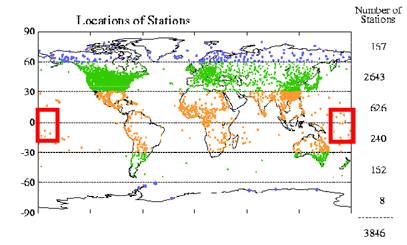
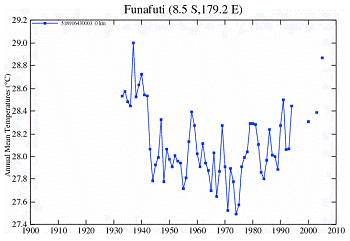
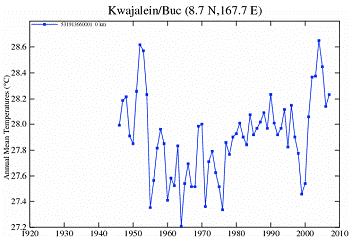
There are very few temperature stations in Oceania with data as far back as 1950. The only ones that exist show warmer temperatures in the 1930s – 1940s.
|
|
Sea Level Rise
The main focus in Oceania relative to global warming is in terms of sea level rise. Tuvalu is one of the “poster-children” for global warming and has been experiencing erosion (for example: “Tuvalu is Drowning” [http://www.salon.com/news/feature/2006/03/31/tuvalu/index_np.html]: “The island nation is slowly being inundated as the ocean rises, and some citizens are fleeing. How will the world handle a flood of "climate refugees"?”). But reality and hype are two different stories. For example, “The Canary is Drowning: Tiny Tuvalu Fights Back Against Climate Change” [http://globalpolicy.igc.org/nations/micro/2002/1203canary.htm]: "They've been making a case in international assemblies seeking assistance, demanding financial repartitions form the industrialized world,… many climate change models say it's too late for Tuvalu"
A paper published in 2010 (Webb and Kench, “The dynamic response of reef islands to sea level rise: evidence from multi-decadal analysis of island change in the central pacific” Global and Planetary Change, [http://www.sciencedirect.com/science?_ob=ArticleURL&_udi=B6VF0-504BT2S-1&_user=10&_coverDate=05%2F21%2F2010&_rdoc=1&_fmt=high&_orig=search&_sort=d&_docanchor=&view=c &_acct=C000050221&_version=1&_urlVersion=0&_userid=10&md5=680c7aa9c40fe9858c15ed09fcf692ee] states: “Low-lying atoll islands are widely perceived to erode in response to measured and future sea level rise. Using historical aerial photography and satellite images this study presents the first quantitative analysis of physical changes in 27 atoll islands in the central Pacific over a 19 to 61 year period. This period of analysis corresponds with instrumental records that show a rate of sea level rise of 2.0 mm.y-1 in the Pacific. Results show that 86% of islands remained stable (43%) or increased in area (43%) over the timeframe of analysis. Largest decadal rates of increase in island area range between 0.1 to 5.6 hectares. Only 14% of study islands exhibited a net reduction in island area. … Results contradict existing paradigms of island response and have significant implications for the consideration of island stability under ongoing sea level rise in the central Pacific. First, islands are geomorphologically persistent features on atoll reef platforms and can increase in island area despite sea level change. Second; islands are dynamic landforms that undergo a range of physical adjustments in responses to changing boundary conditions, of which sea level is just one factor.” One of the Tuvalu atolls – Funafuti – had almost a 30% increase in area [http://wattsupwiththat.com/2010/06/03/the-irony-it-burns/#more-20158]
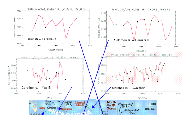
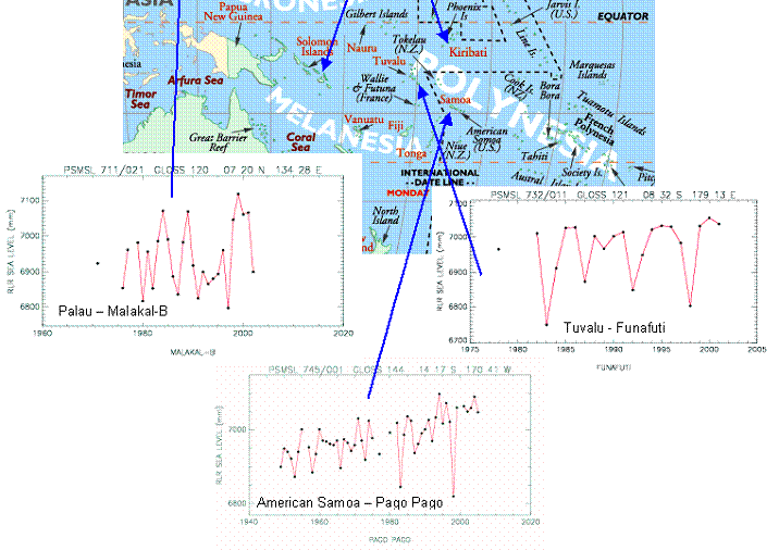
The following image shows a series of seal level plots for various islands in Oceania (sea level plots are from the UK-based Permanent Service for Mean Sea Level database [http://www.pol.ac.uk/psmsl]). Tuvalu is included here as are all available “long-term” sea level stations in the PSMSL database. Sea level rise is at most very small in most of these locations, including Tuvalu.
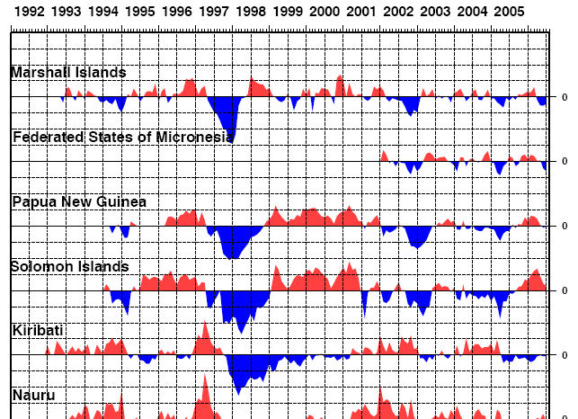
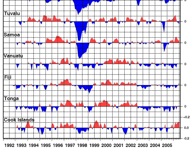
The following figure shows the sea level anomalies from the SeaFrame sea level study including many of the same islands shown above. [http://www.bom.gov.au/ntc/IDO60033/IDO60033.2006.pdf ]
|
|
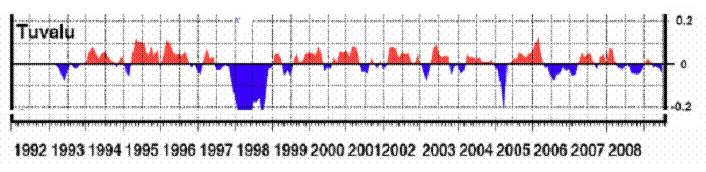
Tuvalu
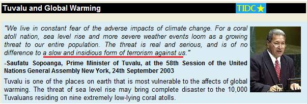
Al Gore’s Inconvenient Truth claimed that Pacific atolls had already had evacuated due to rising sea levels caused by anthropogenic global warming and that sea levels could rise by 20 feet “in the near future”. (Both “facts” were found to be false by a British judge [http://business.timesonline.co.uk/tol/business/law/article2633838.ece])
The tropical Pacific country of Tuvalu is the typical poster child for the alarmist scenario since the coral islands’ elevations are all below 15 feet elevation and stormy high tides regularly cause erosion problems.
The following is from http://www.tuvaluislands.com/warming.htm
Then there’s reality. The following figure shows sea level data at Funafuti, Tuvalu to June 2009 (From Fig 11 in [http://www-cluster.bom.gov.au/ntc/IDO60102/IDO60102.2009_1.pdf]) The figure speaks for itself.
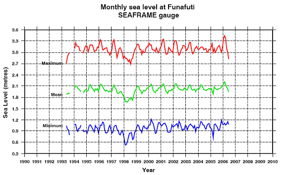
The following figure provides a closer look at the SeaFrame sea level data at Funafuti, Tuvalu for 1994 to 2006.
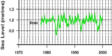
The following figure shows the mean sea level for Tuvalu from the Joint Archive of Sea Level data (same report as cited above), with data starting in 1978.
Tuvalu issued a postage stamp sheet in 2009 featuring the “First Family of the United States of America”. Included on the stamps are President Barack Obama, the First Lady Michelle Obama, daughters Malia & Sasha, and the First Portuguese Water Dog Bo. Tuvalu beat the Nobel prize givers to the ass-kissing podium. (Although Liberia was the first country to release an Obama stamp sheet, other countries have also – including Guinea, Tanzania, Palau and Sierra Leone.)
|
|
|