Global Warming Science: www.appinsys.com/GlobalWarming
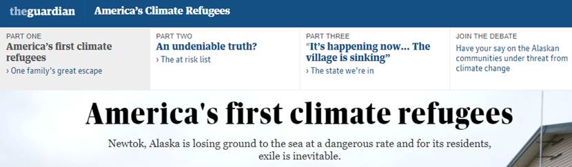
Newtok, Alaska – Canary in the Fake News Coal Mine, Climate Refugees in Chaos
[last update: 2018/01/30]
|
The Alarmists
“At a Senate hearing on Thursday, Sen. Bernie Sanders called Alaska the “canary in the coal mine” on climate change and cited threats to Native American communities from rising seas as a result of global warming. … The village of Newtok, Alaska, near the Arctic Circle, may be underwater by 2017, according to the U.S. Army Corps of Engineers, Sanders noted…. “Some of you are in favor of more production of fossil fuel which is ultimately destroying the very communities you live in. That does not make a lot of sense to me,” Sanders asked witnesses at the Senate Energy and Natural Resources Committee hearing.”
“Eventually all of the villagers will have to leave, becoming America's first climate change refugees… Yup'ik Eskimo have been fishing and hunting by the shores of the Bering Sea for centuries and the villagers reject the notion they will now be forced to run in chaos from ancestral lands.”
|
|
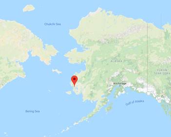
Newtok, Alaska
Google maps shows the location of Newtok:
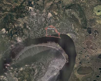
“Newtok is located on the Ninglick River north of Nelson Island in the Yukon-Kuskokwim Delta Region… In the late 1950s, the village was relocated from Old Kealavik ten miles away to its present location to escape flooding… Due to severe erosion, the village has started to relocate to a new site called Taqikcaq, approximately 5 miles away on Nelson Island.” http://www.explorenorth.com/alaska/history/newtok-history.html
So the Sanders/MSM alarmists are conflating river erosion with sea level rise – and the river flooding already forced the village to relocate previuosly in the 1950’s
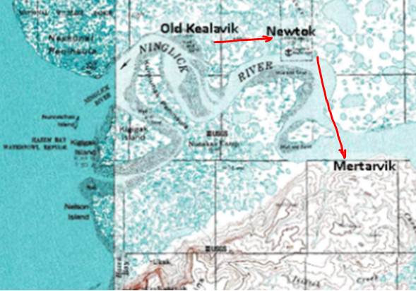
According to Commerce Alaska: Newtok is “located on a sweeping bend of the Ninglick River, north of Nelson Island near the Bering Sea. The village is located within the boundaries of the Yukon Delta National Wildlife Refuge on the soggy, lowland plain of the Yukon-Kuskokwim Delta, one of the largest river deltas in the world.” The following image shows the villages and the so-called “refugees’” migration path: Old Kealavik -> Newtok (1950s) -> Mertarvik 2010s or maybe 2020s.
They are running in chaos from their ancestral lands, according to the Guardian. In reality, they moved about 10 miles 60 years ago due to river flooding, and will move about 10 miles again due to river erosion. And their new village will be closer to the other villages of the same Qaluyaarmiut people on Nelson Island! The Guardian is all about fake news.
|
|
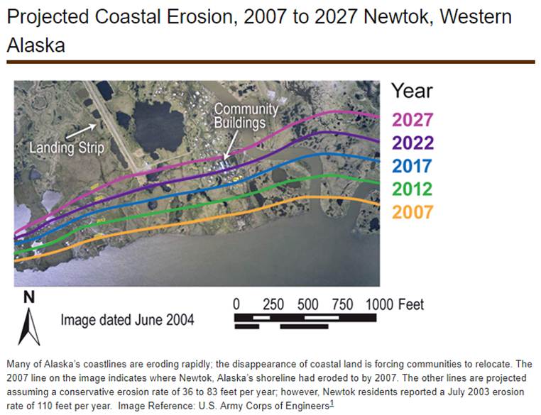
Newtok Erosion
(I remember an old saying – “Never build on a flood plain” – guess what a large river delta is?)
“In the three decades that followed the community's settlement at Newtok, residents became increasingly aware that the north bank of the Ninglick River was rapidly losing ground.”
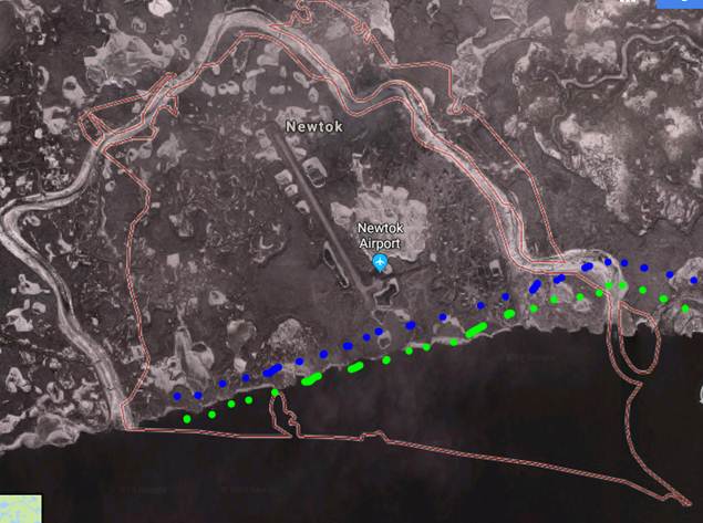
Google maps satellite imagery as of February 2018, with the approximated 2012 and 2017 predicted erosion lines from the above image shown as dots.
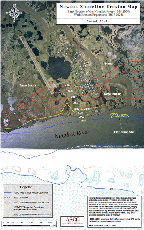
Another erosion image showing both banks of the river:
|
|
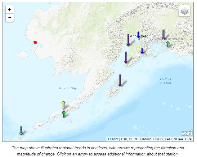
Sea Level
Although Newtok is on a river in a major river delta – not on the ocean, a look at the nearest sea level stations is warranted since that’s what the alarmists erroneously say is causing the problem.
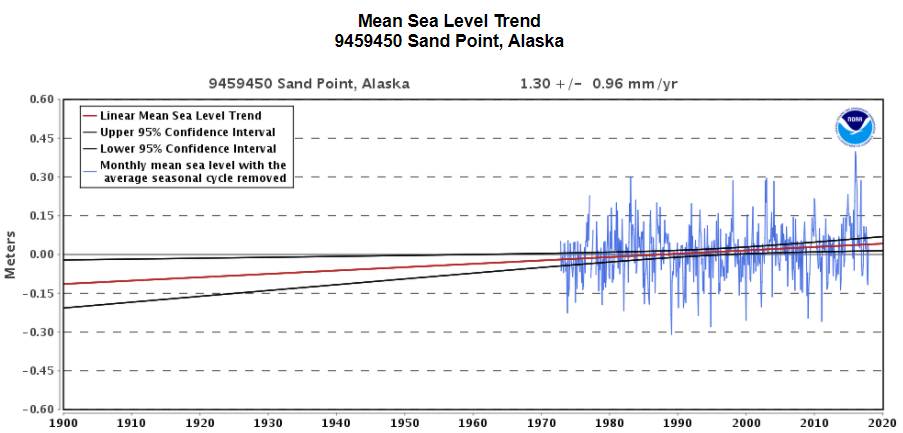
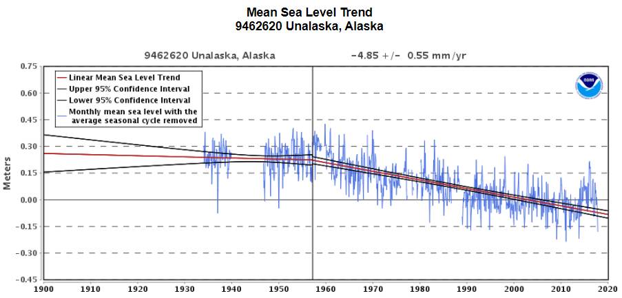
The following map and data are from NOAA (https://tidesandcurrents.noaa.gov/sltrends/sltrends.html ) and show the sea level stations in Alaska (the red dot shows the location of Newtok).
Alaska’s sea levels have been falling since the last ice age due to isostatic rebound from the weight of the ice sheets. The only stations with increasing sea level have very short term data.
At the top of this article I referred to Bernie Sanders: “Bernie Sanders called Alaska the “canary in the coal mine” on climate change and cited threats to Native American communities from rising seas as a result of global warming. … The village of Newtok, Alaska, near the Arctic Circle, may be underwater by 2017”. Given that sea levels in Alaska are falling due to isistatic rebound of that part of the continent, Bernie shows that he is especially out to lunch with his lie of attributing the demise of these communities to “rising seas as a result of global warming”.
|
|
MSM Fakery
http://billmoyers.com/story/trump-climate-change-alaskan-villages/
“For years, residents of coastal villages in Alaska have watched as their towns are gradually swallowed by the sea, or as they sink into the ground when the permafrost beneath their foundations turns from solid ice into swampland. Ground zero for these problems is Newtok, an Alaska Native village in the Yukon River Delta that has been trying to relocate for decades as the permafrost erodes beneath it and the nearby Ninglick River eats away at its banks at a rate of 70 feet per year.”
Duh… Bill Moyers – please learn to use the Interwebs that yer buddy Gore created for us all, and you might learn some facts instead of having to spew more fake news.
|


 Kodiak Island
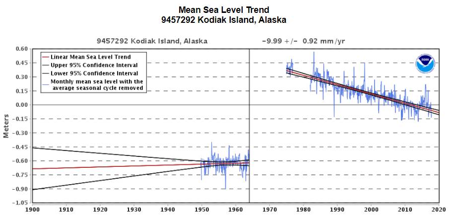
|
|