Global Warming Science - www.appinsys.com/GlobalWarming
Bangladesh
[last update: 2010/11/03]
|
Bangladesh is considered to be one of the countries that is most vulnerable to the effects of global warming. (See http://www.appinsys.com/GlobalWarming/Vulnerability.htm)
|
|
|
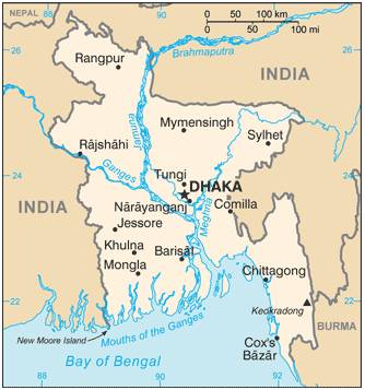
https://www.cia.gov/library/publications/the-world-factbook/geos/bg.html |
According to the CIA factbook:
Bangladesh is “slightly smaller than Iowa” with 156 million people
“most of the country is situated on deltas of large rivers flowing from the Himalayas: the Ganges unites with the Jamuna (main channel of the Brahmaputra) and later joins the Meghna to eventually empty into the Bay of Bengal”
“many people are landless and forced to live on and cultivate flood-prone land; waterborne diseases prevalent in surface water; water pollution, especially of fishing areas, results from the use of commercial pesticides; ground water contaminated by naturally occurring arsenic; intermittent water shortages because of falling water tables in the northern and central parts of the country; soil degradation and erosion; deforestation; severe overpopulation”
|
|
Floods
Flooding is an annual event in Bangladesh. “Bangladesh generally experiences four types of floods. Flash floods occur during mid-April before the on-set of the south-westerly monsoon. Rain-fed floods generally happen in the deltas in the south-western part of the country and are increasing in low-lying urban areas. River floods are the most common; the areas are inundated during monsoon season along the river and in cases far beyond the riverbanks. Storm surge floods occur along the coastal areas of Bangladesh, which has a coastline of about 800 km along the northern part of Bay of Bengal. In case of important cyclones the entire coastal belt is flooded, sometimes causing great loss of lives. Coastal areas are also subjected to tidal flooding from June to September.” [http://www.apfm.info/pdf/case_studies/bangladesh.pdf]
Upstream deforestation may contribute to increased floods. “A rapid increase in population in the Indian Subcontinent over the course of the 20th century has resulted in an acceleration of deforestation in the hills of Nepal to meet the increasing demands for food and fuel wood. Deforestation of steep slopes is assumed to lead to accelerated soil erosion and landslides during monsoon precipitation, which in turn is believed to contribute to devastating floods in the downstream regions, such as in Bangladesh. Deforestation within Bangladesh also contributes to the soil erosion. The amount of forest cover in Bangladesh was reduced from 15.6% in 1973 to 14.6% in 1985-86, and eventually to13.4% in 1987. A minimum of 25% forest cover is suggested for a healthy ecosystem. The amount of forest cover in Bangladesh at the present time believed to be less than 10%” [http://www.sdnbd.org/sdi/issues/floods_drainage/2004/disaster_management/ flood_control_through_best_management_practices.htm]
Land subsidence is a problem as the overpopulated country becomes more urbanized. “Rapid population growth creates extra pressure on the land of already overcrowded Bangladesh. Agricultural lands give way to housing developments and roads. Urban population has increased from 1.81 million (4.33% of total population) in 1951 to 25.2 million in 1990. The current urban population is more than 30 million (25% of total population), and is projected to exceed 58 million (36% of total population), by the year 2010.” … “Subsidence and compaction reduce land elevations with respect to sea level. No direct measurements of subsidence or compaction are known for Bangladesh. However, the groundwater table in Dhaka City has had a considerable lowering by as much as 9 to 12 meters over the last 3 decades. Experience in other countries indicate that at least 9 meters of permanent lowering of groundwater table causes 30 cm of land subsidence. Therefore, it is likely that land elevations in many parts of Dhaka City have been lowered by up to 30 cm, contributing to increased flood depth.” [http://www.sdnbd.org/sdi/issues/floods_drainage/2004/disaster_management/ flood_control_through_best_management_practices.htm]
|
|
|
Sea Level
Since most of the country is on deltas of large rivers (draining from the Himalayas and a large portion of India) where summer monsoon rains occur, flooding is a regular occurrence. With this low elevation of most of the country, sea level rise is a concern.
Hofer and Messerli (“Floods in Bangladesh: History, Dynamics and Rethinking the Role of the Himalayas”, United Nations University Press. 2006) state: “Massive floods have occurred regularly before man’s impact on the large river basins began. There is no statistical evidence that the frequency of flooding in Bangladesh has increased during the 20th century.”
“Bangladesh may avoid losing a predicted fifth of its land to rising sea levels because of accumulated sediment being washed down by Himalayan rivers … the Himalayas — relatively young mountains with a loose structure — have been losing more than a billion tonnes of sediment every year, some of which has been building up the land in the river estuaries below. … The scientists analysed how the two rivers and the land around them changed in response to the changing climate from 1943 to 2008. They found that the rate of sediment addition was more than the rate of soil erosion during this period — the country gained nearly 1,800 square kilometres of new land, almost five times the area of Dhaka. … But IPCC chairman Rajendra Pachauri warned against "jumping to conclusions"” [http://www.scidev.net/en/news/river-sediment-may-counter-bangladesh-sea-level-rise.html]
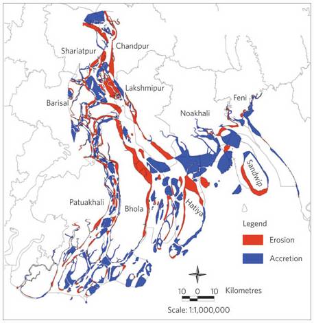
“Of all of the effects of climate change, sea level rise may pose the most pervasive challenge for Bangladesh. Nearly the entire country is a vast, flat delta, where even a modest climb in the height of the Bay of Bengal could push water deep inland if it weren't for the protective barriers along the coast. … Considering elevation alone, even a one-metre rise would swallow about 15 to 20 per cent of Bangladesh's land area, where about 20 million people live today. But such estimates can be misleading, since they leave out some crucial factors. For one thing, Bangladesh's delta is now expanding, as sediments settle along the coast and create new land. "It's adding nearly 20 square kilometres a year in the coastal areas," says Maminul Haque Sarker, a morphologist at the Center for Environmental and Geographic Information Services (CEGIS) in Dhaka. His recent analysis7 of satellite images shows that Bangladesh has been gaining land for decades, and old maps from the early colonial era suggest the country has been growing this way for centuries, says Sarker. "There's a lot of accretion, and a lot of erosion, and they're almost in balance," he says. "We are gaining land — but it is a net loss." That's because the new land isn't of much use right away. For these coastal areas to support many people, they need embankments to protect them from tides and storm surges, and then they take decades to become productive, says Sarker. Many estimates of the land area that would be lost to sea level rise are also misleading because they don't factor in the embankments that protect much of the coast” [http://www.nature.com/climate/2009/0902/full/climate.2009.3.html]
The following figure is from the above reference showing land erosion and accretion.
|
|
|
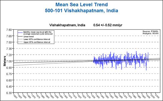
Sea Level Measurements
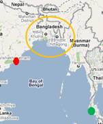
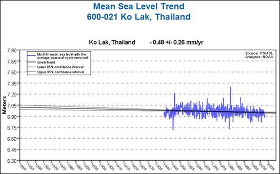
There are no sea level stations in Bangladesh in the PSMSL database – the nearest are in India and Thailand. The following figures show sea level trends for the nearest stations in India (Vishakhpatnam – red dot on map) and Thailand (Ko Lak – green dot on map) plotted at the NOAA sea level data site [http://tidesandcurrents.noaa.gov/sltrends/index.shtml]
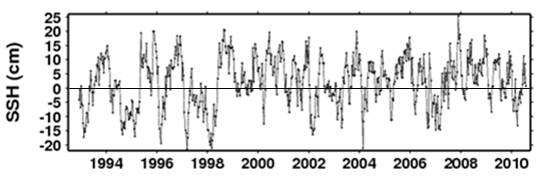
The following plot shows sea level for 21 N , 90 E (just off the coast of Bangladesh) plotted at [http://sealevel.colorado.edu/wizard.php]
None of the sea level data indicate significant rise in sea level for Bangladesh.
|
|
|
Conclusion
The overpopulated country lies in a flood plain of major rivers and regularly has disastrous floods. It is therefore vulnerable even without “climate change”. The available sea level data indicate that rising seas are not a problem; however, sinking land due to overpopulation, urbanization and subsidence creates increasing localized elevation problems.
Although Bangladesh is one of the countries designated as “least developed” by the UN and has 36% of the population below the poverty line, it ranks 49th in the world in terms of reserves of foreign exchange and gold (ahead of Finland and Argentina) and 15th in the world for GDP growth rate. [http://www.photius.com/rankings/economy/reserves_of_foreign_exchange_and_gold_2010_0.html]
Providing aid to Bangladesh in dealing with its problems is one thing; masking the problems in terms of anthropogenic CO2-caused global warming / climate change is dishonest.
|
|
|
|
|